La Ceiba, Honduras, Breaking news − Not! But it would have been! The earthquake occurred at 2:25 a.m. last night in La Ceiba. At 2:35 a.m., I was at the computer to a) check the USGS Earthquake site, and b) to write my blog article! Unfortunately, while the power and cable TV only went out momentarily, the internet connection went out and didn't return until after lunch today. Darn! Can you imagine the extreme frustration of a dedicated blogger wanting to be the first to investigate and write a breaking news story with no way to post it?!
Update: the earthquake was reclassified as 7.3 on the Richter scale.
 Image from: the USGS Earthquake center
 Click the map to view an enlarged version.
Click the link for more detailed information.
The earthquake epicenter was in the ocean about 39 miles (63 km.) NE of the Honduran island of Roatán, only slightly further NW of the island of Guanaja, and about 75 miles NNE (125 km.) of La Ceiba. It was also felt all over Honduras, in Belize, El Salvador, Guatemala, Mexico and Nicaragua. As shown on the map, La Ceiba was barely outside the intensity area VI. The Bay Islands were in intensity areas VI and VII, the entire north coast, including San Pedro Sula, was in intensity area V, while the rest of Honduras was in area IV.
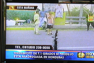
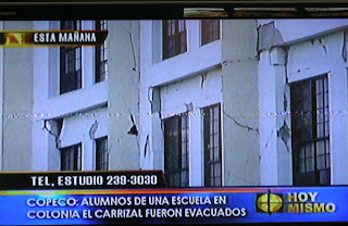
Since I couldn't access the internet, I spent the entire morning watching all of the Honduran television stations for the latest news and have these hokey TV photos to show you. Channel 10 was heavily using Google Earth in their presentations! Impressive! Additionally, the online newspaper sites are now so overloaded that I can't access the latest information. I'm getting the 'acceso denagado' message on every page I try to open. I can see the headlines but the articles won't open. Aaargh!
As near as I can tell, the worst physical damage was the loss of a bridge on the major highway in El Progreso between San Pedro Sula and La Ceiba. This was the old bridge, which is shown in the photo at top, constructed by the French in 1963, and a newer larger bridge, constructed by Japan after Hurricane Mitch in 1998, is right next to it.
 Both were in use, one-way each direction. There will be no problem using the larger bridge as a two-way bridge provided it is not damaged. I'm not certain whether the damage shown in this photo at right is on the new or the old bridge. Latest word is that the larger bridge has been reopened. Hooray for the Japanese! (Update 5/29/09: I found out that this photo reflects damage on the newer bridge, which has since been reopened. I hope whoever analyzed the safety of the bridge knew what they were doing! This bridge gets heavy traffic.)
 Six deaths and 19 injuries have been reported, primarily to people who were asleep in their beds when a wall or ceiling fell on them. From my notes, one death each was reported in Tocoa, Trujillo, La Lima, Yoro, and Gracias. Many minor and a few more severe injuries were reported.
These numbers will change as more information is known by the Honduran authorities and media so if you wish to keep up to date, please check the Honduran online newspapers, which will probably be more accessible later tonight or tomorrow. (See the links page at the top of the blog.) Please keep in mind that the Honduran newspapers often grossly exaggerate the effects of such natural disasters.
 Four churches, the court building in San Pedro, and some houses in several different areas of Honduras were damaged. A few houses collapsed completely and in many cases, for various reasons, it is thought that these particular structures were mal hecho (badly constructed). Some of the muros (concrete fences/walls) that fell were obviously poorly constructed even to our non-expert eyes, i.e., they had virtually no foundation in the ground and insufficient vigas (structural supports).
 A few San Pedro Sula colonias were without electricity. I was amazed that our power and cable were interrupted only momentarily here in La Ceiba. The main highway approaching San Pedro was cracked down the middle of one lane with one side of the road being raised 8-10" above the other. There were also some reports of phones being out so if you are having trouble trying to reach someone in Honduras, don't despair.
Once again, I was impressed with Marcos Burgos, the Commissioner of COPECO (national emergency preparedness agency). He talked on the news for about 20 minutes, without notes, giving full reports of every area of Honduras. He seems a man dedicated to his job.
 We were very lucky that this happened at night and in the area that it did. The USGS stated that being relatively shallow (only about 6 miles or 10 km. deep), the quake had the potential to be much more severe than it was. Overall, I believe that the damage was minimal. Not a consolation to those whose houses collapsed or family members were killed, but all in all, it could have been much, much worse.
To put things in perspective, this is from the US Geological Service earthquake site regarding a similar size earthquake:
"A magnitude 7.5 earthquake occurred near the Guatemala, region 358 km southwest of the location of this earthquake on February 4, 1976 (UTC), with estimated population exposures of 80,000 at intensity IX or greater and 1,017,000 at intensity VIII, resulting in an estimated 22,778 fatalities."
In the case of Honduras' earthquake, intensity areas IX and VIII were in the ocean.
The video of damage on the news primarily showed the same 3 or 4 structures over and over again. I'm sure that we'll see more reports as time passes. Honduran TV stations do not seem to have on-site reporters in outlying locations, not even for emergency reports and cell phone photos or videos, a fact which astounds me. Heck, I would volunteer to do it for them and I'm sure many others would, too! After seven hours of watching TV, I have yet to see a single on-site report from Roatán which was much closer to the epicenter.
Reports from our Honduras Living group members from many parts of Honduras confirm that with a few sad exceptions, earthquake damage was relatively minor. Several houses and some roads were damaged in Roatán. It sure was scary while it was happening.
 Many people are concerned about travel to or from the SPS airport. Steve, our Honduras expert in San Pedro Sula, reported that if the larger El Progreso bridge is closed, there is an alternative route through Santa Rita which will add a minimum of an hour to the trip for those who need to travel to or from San Pedro Sula and the rest of the north coast of Honduras. We only have one highway across the north coast so when a bridge goes out, it can be very difficult to access other parts of the country. (Photo: La Prensa, Honduras)
By the way, there were reports of a tsunami warning, too. The original warning has been canceled. It is definite that there is no risk of tsunami!
The USGS Earthquake site has several maps charting various aspects of the earthquake. If you felt the earthquake, you can give your experience and view the results of other people who responded in various charts and tables. I suppose that this helps the USGS in their research and statistics. The Earthquake site is a good site to bookmark for future reference. It has information in both English and Spanish almost instantly whenever an earthquake has occurred anywhere in the world.
Next: My own personal reaction to the earthquake.
Related articles:
Not one Honduran quake but three
Make that four Honduran earthquakes


 Welcome to my Blogicito —


