I finally got to sleep about 3:30 a.m. on Friday, the night after the first earthquake − only just in time to be awakened by Pancho the rooster! ;-) Once I got back to sleep, I was so sleep deprived that nothing was going to wake me up and I mean nothing...
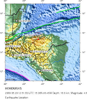
Not even another earthquake! Yes, that's right. Another 4.6 earthquake struck at about 6:51 a.m. on Friday. This one was the closest yet, only 35 miles (55 km.) southeast of La Ceiba and was a land quake rather than an offshore quake, like the previous three. Looking at a more detailed map, it appears to have occurred between Olanchito, Yoro, and Pueblo Viejo, Olancho.

Amazingly, I've seen nothing in or on the Honduran news about this one or the other two which occurred after the first. Granted, they were smaller, but it seems to me that they deserve some mention. Apparently the media does not keep up with USGS Earthquake site as many are still reporting the original quake as a 7.1, even though it was revised yesterday to a 7.3.
Personally, I think the Honduran government and media are torn between making more of the situation (for foreign aid purposes) or down playing it (for tourism purposes). Sorry, that's my cynical side showing again. ;-D
I'd like to encourage anyone here in Honduras, or elsewhere when you feel an earthquakes to complete the short, simple questionnaire "Did you feel it? − Tell us!" on the USGS site. I assume that the USGS uses that feedback in their analysis, but it can serve another purpose, too. People looking for information about the earthquake effects in smaller areas for which there might not be much in the news can review those results and at least get a general idea about how severe the quake was in that area. It's a public service. ;-)
In order to complete the questionnaire, you'll first need to find the page for the specific event that you felt which is probably easiest from the map. Click on the event to see when that earthquake occurred. If it is the right one, click on the "Did you feel it" link.
Keep in mind, though, that the USGS is currently reporting some of our Honduran earthquakes at the wrong time! The actual times are one hour earlier. To make matters even more confusing, on some pages (like the Spanish version) the same quake is shown at the correct local time and others (English version) it is not. I've written them to point this out and I hope that some of you will, too, so that they will correct this information. After all, a scientific site should not have errors like this!
If you should happen to be reading these earthquake articles later, it may be that the quake ratings have changed. USGS continues to modify the rating as more information is obtained. Additionally, if you read them more than a week after they were written, I think that many of these links that I've given you will no longer function since they are currently posted under a "recent events" URL. Historical earthquake events can be found at .... well, that is a difficult site. At the moment, I cannot find the list that I saw early. Sorry, you are on your own.
To summarize, the USGS Earthquake site is a complete moving target! Very annoying when you are trying to link to information. If anyone knows how to get a permanent link, I would appreciate the information. − Not that I'm expecting any more earthquakes, but you never know, right?
Here is a summary of the recent Honduran quakes (times are UTC, not local) from the USGS site:
| MAG | UTC DATE-TIME y/m/d h:m:s | LAT deg | LON deg | DEPTH km | Region | |
|---|---|---|---|---|---|---|
| MAP | 4.6 | 2009/05/29 12:51:03 | 15.359 | -86.463 | 10.0 | HONDURAS |
| MAP | 4.5 | 2009/05/29 02:45:44 | 16.118 | -87.591 | 10.0 | OFFSHORE HONDURAS |
| MAP | 4.8 | 2009/05/28 09:06:25 | 16.353 | -87.377 | 10.0 | OFFSHORE HONDURAS |
| MAP | 7.3 | 2009/05/28 08:24:45 | 16.730 | -86.209 | 10.0 | OFFSHORE HONDURAS |
Related articles:
Not one Honduran quake, but three!
Earthquake - The first time the earth moved for me, then again and again and again
Terremoto! 7.1 Earthquake in Honduras


 Welcome to my Blogicito —


